Luong Nguyen Viet
The aim of the project is to use the Remote Sensing & GIS technology in managing natural resources at the International Biosphere Reserve Can Gio, Ho Chi Minh city is better now. The long-term aim is to build and develop methodology, application in RS & GIS technology for the management, conservation, rehabilitation and development of mangrove forests in Viet Nam.
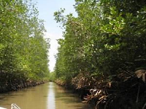
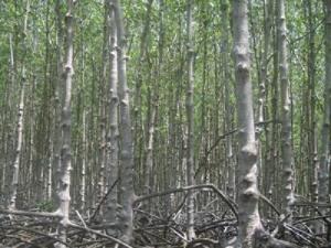
Can Gio mangrove forest lies entirely within the Can Gio district of Ho Chi Minh City. It is one of 18 districts of Ho Chi Minh city and area cover about is over 70,000 ha. From the north to the south it covers a distance of 35 km and at the middle portion, is about 30 km wide. The Can Gio mangrove forest is regarded as the "Green Lungs" of the region. Specially, on January 21st, 2000, MAB/UNESCO committee recognized Can Gio mangrove forest as an International Biosphere Reserve. There are some 58,000 people living within the biosphere reserve boundaries, 54,000 of which live in the transition area.
The local people are of different origins and there is a mixture of cultures and way of life. The main economic activities are agriculture, fisheries, aquaculture, salt production and tourism. Some households here, they must earn their living by catching crabs, molluscs and collecting fire wood etc., from mangrove forest. So, the management, protection and development of mangrove forests, it is very difficult here. Because fewer rangers and equipment for protection restrictions, qualifications and capacity of the staff here is limited, example; the use of new technology such as RS and GIS technology.
At present, Can Gio Biosphere Reserves is being protected and developed. However, the application of remote sensing technology in forest study in Vietnam only limited the building of land cover maps with the classes (dense forest, open forest, shrub etc.). But, the application of this technology for detection or recorded to the growth, the development and the inner change of association structure of flora are not interesting and has never been done. Therefore, the results of this study is really necessary for the planning, management, conservation, rehabilitation and development of Can Gio Biosphere Reserve.