Pierre Ngangoumoun
The project aims to assess deforestation and degradation at the western periphery of the Dja Biosphere Reserve in Cameroon and to start to build the technical capacity of the local communities in assessing and monitoring the stocks of above-ground carbon in community and state-owned forests.
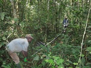
Community member measuring tree height in the forest
The Dja Biosphere Reserve covering some 526,000 ha of tropical evergreen rainforest in southern Cameroon constitutes an important carbon sink. Under the influence of the Atlantic, Congolese and semi-deciduous forests, the Dja Reserve is also an important conservation area harbouring an assemblage of species of wild fauna and flora that typify the entire Congo Basin region. It also offers the livelihood support base for the many thousands of people including the indigenous Baka pygmies living inside and outside the reserve. The periphery of the Dja reserve is the scene of complex land use options with a mosaic of logging concessions, farmlands and mining concessions. This makes the Dja region an interesting area where to pilot land and resource management approaches such as the emerging scheme on reduced emissions from deforestation and degradation or REDD that best reconcile the triple needs of climate change mitigation, community development and biodiversity conservation.
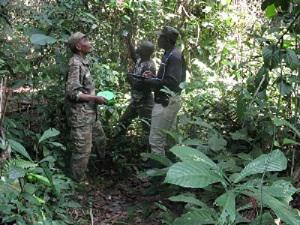
Tree measuring and identification by local people
Cameroon, like other countries throughout the Congo Basin, is struggling for a number of reasons to get to speed with issues related to the role of tropical forests in the climate change debates. While the discussions at national level have focused mainly on the country’s readiness strategy for REDD, discussions on site-level or subnational interventions have not even started and there are currently no tangible case studies to inform the national debates.
This pilot project is being set up with the overall objective of appreciating in a participative way, the situation of deforestation and degradation at the western side of the Dja Reserve and to evaluate the stocks of renewable natural resources in some pilot community and stated-owned forests using spatial analysis techniques and the recent advances in spatial information technology. Specifically, this project is working to achieve the following specific objectives:
- Ascertain de current scale of anthropogenic damages to some forest blocks on the western side of the Dja reserve as well as the trends in deforestation and degradation.
- Test out the recent methods and technology used by the University of Twente “Kyoto: Think Global Act Local” (http://www.communitycarbonforestry.org) or K:TGAL on community participation in the assessment of the carbon stocks in a forest and its sequestration potential.
- Estimate the woody biomass and carbon sequestration potential of some forest blocks at the western side of the reserve under different ownership and management regimes (state vs community) and build local capacity.