Taufiq Afdhal
This research project has several primary objectives: first, to identify the dynamics of forest cover change, which serves as the habitat for the Sumatran tiger; second, to project the future landscape and habitat of these tigers; and third, to assess the landscape connectivity in West Sumatra, which acts as a corridor for Sumatran tigers. Quantitatively, the research aims to measure the extent of forest areas and suitable habitats for tigers and their prey, as well as the forest segments that function as connectivity corridors between forested landscapes throughout West Sumatra. Additionally, projections will be made up to the year 2050 to determine which forest and habitat areas are likely to persist or be lost. Qualitatively, the project will evaluate the functional connectivity between two landscapes to determine if these areas are used by Sumatran tigers as corridors. This will be done by analyzing occupancy data of Sumatran tigers in connected areas. Previous occupancy data for Sumatran tigers in West Sumatra, collected in collaboration with Yayasan SINTAS Indonesia, will be used in this project. The results will help identify villages within these connectivity areas that are at risk of human-tiger conflicts, providing a basis for future interventions by stakeholders to prevent such conflicts.

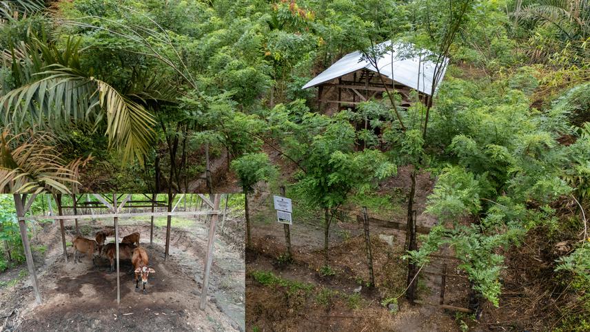
A survey of the tiger-proof enclosure design built by Yayasan SINTAS Indonesia and the Natural Resources Conservation Agency in a village that has previously experienced Tiger-Human conflict. ©Yayasan SINTAS Indonesia.
The project's outputs include government interventions through community outreach to preserve vulnerable forest areas by focusing on community engagement activities in those regions. The project will also recommend potential forest areas that can serve as connectors between landscapes, evaluating their effectiveness through monitoring to ensure they function as tiger corridors, thereby reducing human-tiger conflicts. The research will focus on villages prone to conflicts within these connectivity areas, using historical conflict data and livestock population statistics to guide the selection. In these communities, surveys will be conducted to understand activities near forest areas, followed by outreach on sustainable farming and livestock practices. The project will also support the construction of tiger-proof livestock enclosures, modelled after a successful program by Yayasan SINTAS Indonesia, to mitigate human-tiger conflicts in high-risk areas.
Header: An aerial view of the fragmented landscape caused by built-up areas in the Air Putih Nature Park Conservation Area, which serves as a connecting corridor between the Rimbang Baling Wildlife Reserve and the Nature Reserve. ©Taufiq Afdhal.